(UUID : 04b62f8a-3abe-4c74-95c3-c28bf2831d37)
 QR Code
Sample Type of Object
Rock
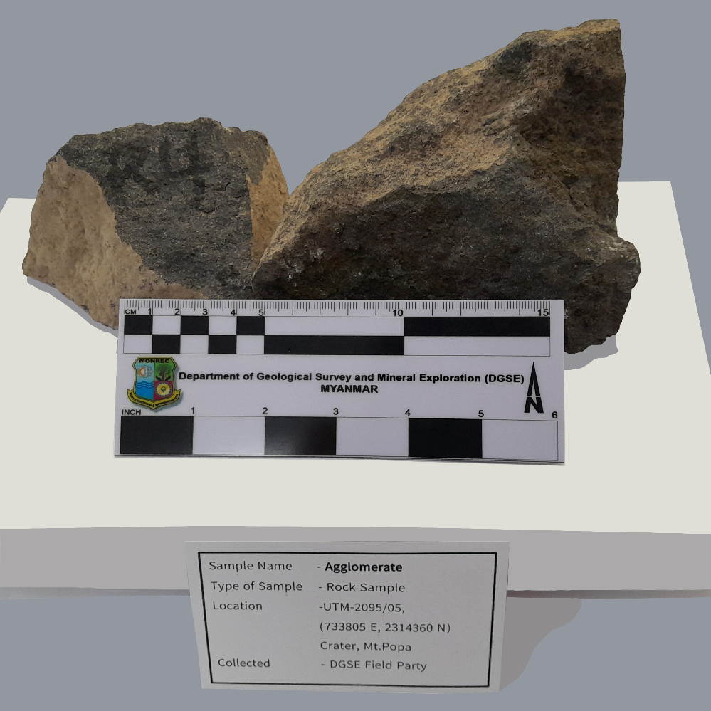
Sample Name
Agglomerate
Sample ID (Self-granted ID)
MM_Rock_17_2023
Material
Rock
Field Name
Geological Survey in Crater, Mt.Popa, Kyaukpadaung Township, Mandalay Region.
Sample Description
An agglomerate is a material formed by objects sticking together and forming clumps. Agglomerates are pyroclastic igneous rocks that consist almost wholly of angular or rounded lava fragments of varying size and shape. Agglomerate is a pyroclastic coarse accumulation of blocks of volcanic metarial that contains atl least 75% bombs, rounded clasts in a matriix of lava or ash. Reddish Brown color, Fine to medium grained agglomerate.
Age
0.001 ~ 1.806
Age(unit)
Million Years (Ma)
Geological Age
Recent
Geological Unit
Recent
Collection Method
Manual
Collection Method Description
Mineral Database
Size
22 cm x 15 cm x 10 cm
Size(unit)
cm
Comment
Geological Survey in Crater, Mt.Popa, Kyaukpadaung Township, Mandalay Region.
Purpose
Museum
Tag
Elevation
1200 ~ 1400
Nav Type
GPS
Name of Physiographic Feature
Mineral Deposit Area
Location Description
Geological Survey in Crater, Mt.Popa, Kyaukpadaung Township, Mandalay Region.
Locality
Crater, Mt.Popa, Kyaukpadaung Township, Mandalay Region.
Locality Description
Myanmar has internationally significant monumental geosites suitable for the establishment of geoparks, such as Mt Popa Volcano near the cultural city of Pagan, which has a geological as well as a national/historical heritage, and the Hukuang Valley in Kachin State. The CVAB is characterized at Mt Popa by calc-alkaline to alkaline volcanic rocks (e.g. Stephenson & Marshall 1984; Maury et al. 2004). Manganese also occurs as epigenetic deposits in andesitic volcanics at Kyaukpadaung, Mt Popa area.
Country
Myanmar (Burma)
State/Province
Mandalay Region
City/Township
Kyaukpadaung Township
Field Program/Cruise
Platform Type
Platform Name
Platform Description
Launch Type
Launch Platform Name
Launch ID
Collector/Chief Scientist
Department of Geological Survey and Mineral Exploration, Field Party.
Collector/Chief Scientist Address
Department of Geological Survey and Mineral Exploration, Naypyitaw, [email protected]
Collection Date
Collection Time
Current Archive
Museum
Current Archive Contact
Original Archive
Museum
Original Archive Contact
Depth in Core
Core Depth(unit)
File Format
JPEG
File Title
Agglomerate_MM_Rock_17_2023
URL
URL Type
URL Description
Document File
CC License
CC BY-NC - The author is free to use, but not for profit.
Copyright
The copyright of this data is held by CCOP.
Data Registrant
Registration Date
2023-02-07

Copyright © CCOP Technical Secretariat
CCOP Building, 75/10 Rama 6 Road, Phayathai, Ratchathewi, Bangkok 10400 THAILAND